PRECISION IN EVERY OPERATION
EC100 is a flagship 3D excavator guidance system built for large-scale projects with advanced jobsite requirements, offering highprecision guidance, dependable performance, and seamless design data integration to support demanding excavation tasks with confidence.
Developed for Demanding Jobsites
Road construction, slope work, and fine grading demand high accuracy and stable performance. EC100 delivers reliable 3D guidance to help operators execute work precisely according to the design data
3D Electronic Fencing System
Equipped with 3D geofencing, real-time attitude sensing, and voice alerts, it helps prevent over-excavation for safer and more precise excavation.
Global Coordinate Systems Multi-Layer Support
6,000+ predefined coordinate systems worldwide. Grid and geoid models are downloaded online for instant use and fast configuration in new working areas.
Multi-Layer support
Supports DWG, DXF, SHP, KML, and XML data formats, with efficient layer management and rendering for smooth multi-layer workflows.
Adapted for Dredging Operations
Built for dredging and waterway construction, with IP67/68-rated components, a roof-mounted GNSS antenna, and an amphibious kit for reliable performance in harsh environments
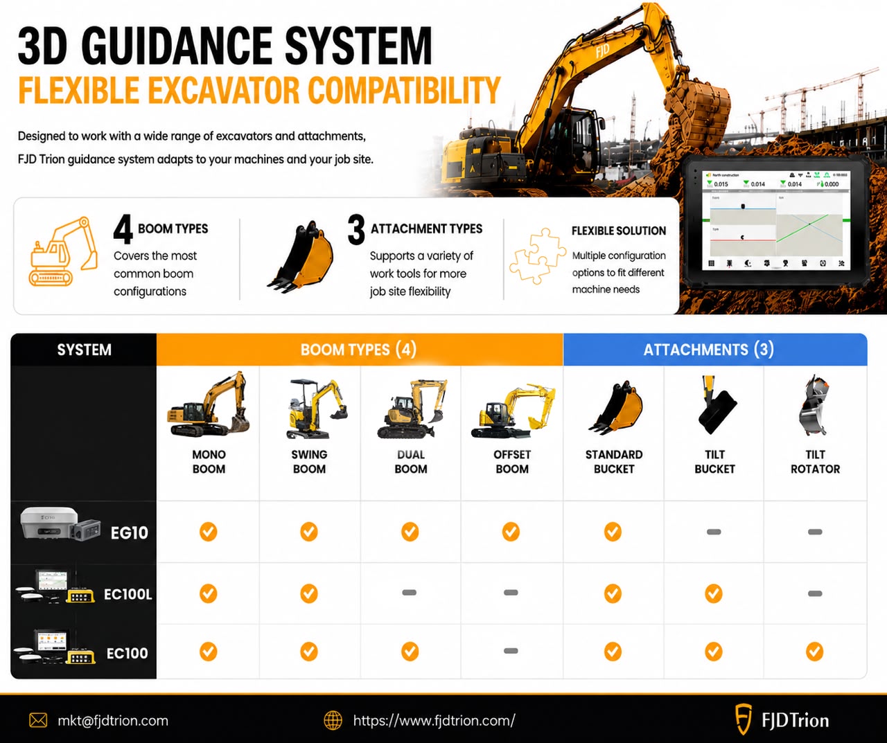
Wide Excavator Compatibility
Works seamlessly with swing, offset, and standard booms, adapting to different excavator types for efficient, accurate performance across diverse jobsite conditions.
FJD TRION TERRAMIND — BRINGING CLARITY TO YOUR JOBSITE MANAGEMENT
Device Management: Real-time machine locations,status, and utilization allow on-site dispatchers to coordinate efficiently and improve equipment use.
Project Management Centralized project progress and resource data help managers track construction pace and allow leadership to monitor risks.
Cross-Team Collaboration Cloud-synced design and field data support more efficient task execution in the field, reducing communication and streamlining workflows.
RELIABLE PERFORMANCE ON COMPLEX JOBSITES
1) Water Conservancy & River Engineering
2) Mine Bench & Pit Planning
3) Airfield Modeling
4) Bridge Substructure Construction
5) Earthwork for Highway Roadbeds
6) Utility Tunnel & Precision Trenching Works
7) Airfield Modeling
8) Precision Slope Grading for Highways